Oct. |
William McAninch (b.bef.1765, age at least 30-31) married "Doshia Dosey" (Laodieca? |
1796 |
Ladosha? Ladisha?) (Dawson? Lawson? Rawson? Rosson? Rowson?), on 7 Oct, 1796, in |
|
Greene County, eastern Tennessee. Shortly after the marriage, William McAninch, his oldest |
|
known son James (probable age 10-11 in 1796), and his new wife went through the |
|
Cumberland Gap and down the Wilderness Road to Lincoln County, Kentucky, leaving in |
|
the fall and traveling through the winter, when the roads were passable. Notes [GrnT] [Jms] |
|
|
1797 |
We do not know why William McAninch chose to settle in the "Fishing Creek" area of |
|
Lincoln County in 1797, south-west of Stanford, but we do know that Daniel McAninch |
|
and his family followed them down the Wilderness Road and also settled in the same area. |
|
|
Early Lincoln County Records |
|
|
|
|
The Commissioners’ Books, land records (surveys, deeds, court records) and tax records, |
|
are the best sources for tracing early McAninch activities here in the 1797-1807 period. |
|
|
|
Each of the three districts in Lincoln County had a Commissioner responsible for his district, |
|
possibly a militia captain, a minister, or another local leader appointed by the county court. |
|
The Commissioner rode his district and recorded men available for the militia, land acreage |
|
and tax rates, location in a watercourse / watershed area, and other information. These early |
|
Commissioners' Books are the most valuable source of specific information for this time. |
|
|
|
The "McAninch in the Lincoln County Kentucky, Tax Books 1787-1805" extraction from |
|
the early Lincoln County Commissioners' Books was published in early 1994. [LCT] |
|
|
|
The 1765-1846 "Time Line, McAninch Events, Early Lincoln / Pulaski / Casey Counties, |
|
Kentucky" (including 1797-1807) was published later that same year, August 1994. [TLin] |
|
|
|
Early Kentucky land records and tax records are described in multiple sources. [KLR] |
|
|
|
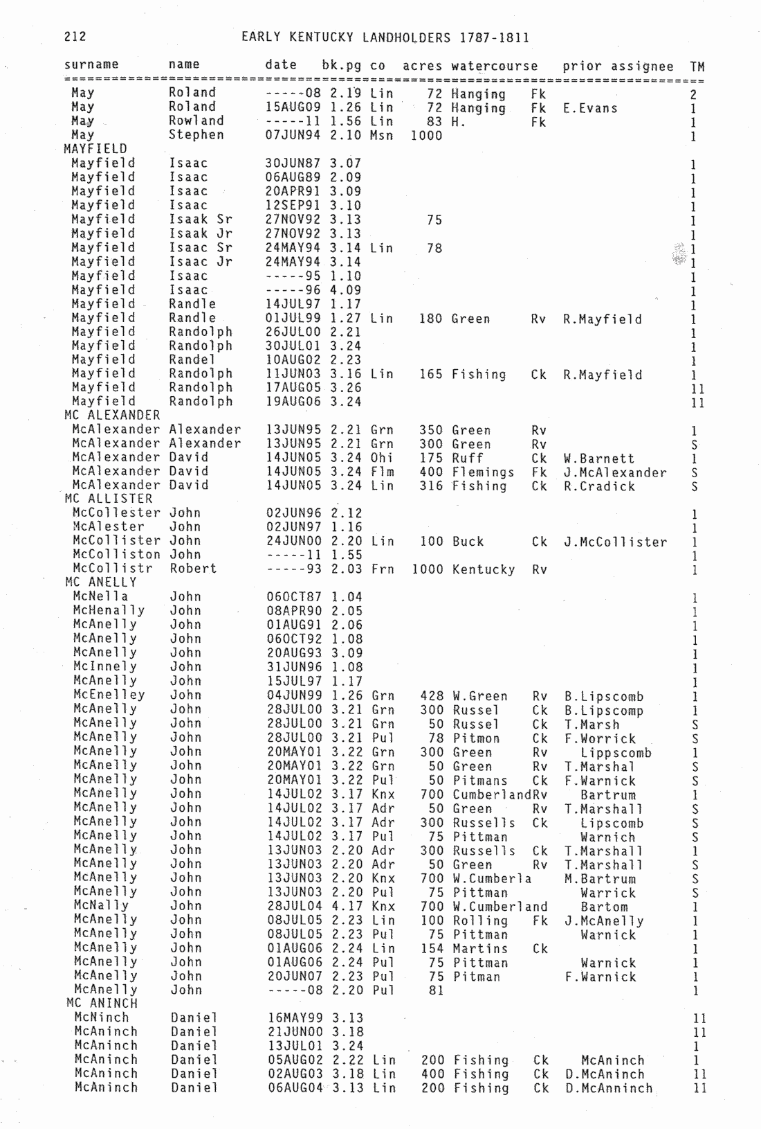
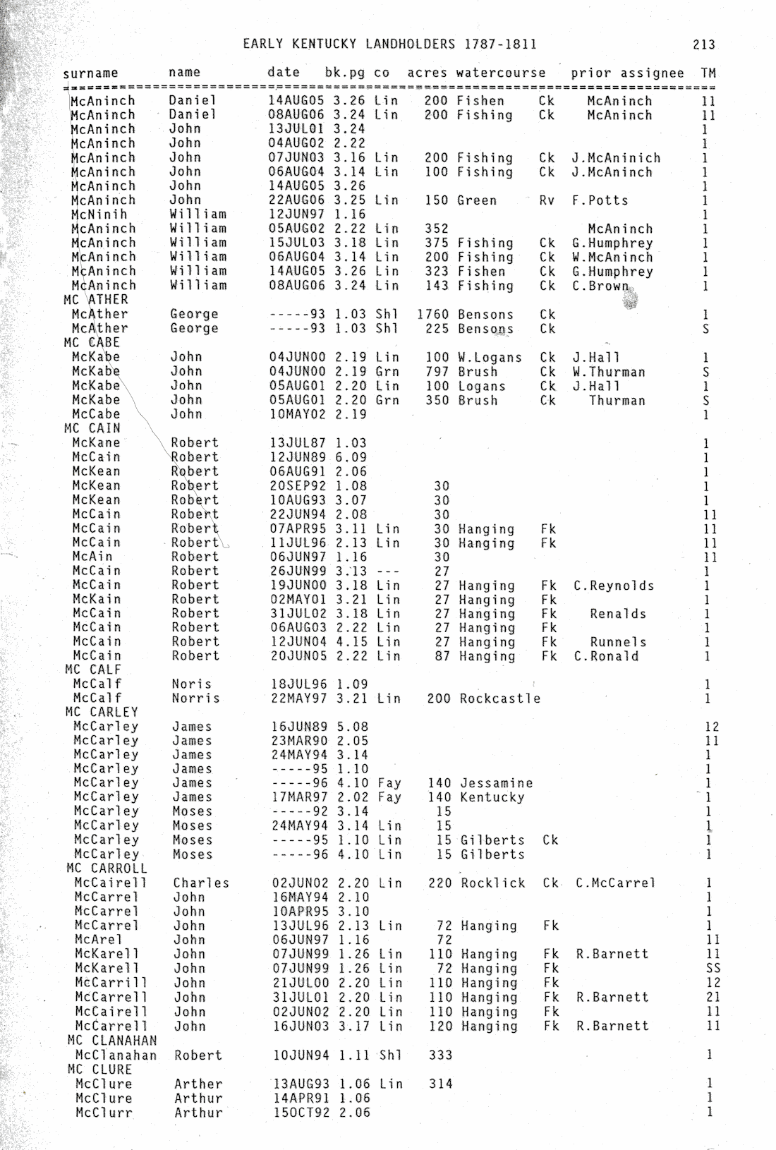
The Early Kentucky Landholders, 1787-1811 book indexes these tax records, with 20 |
|
McAninch entries (Daniel, John, and William) on two pages [EKL] [EKL p212] [EKLp213] |
|
|
|
Three McAninch land survey records have been indexed in "Grants South of Green River" |
|
section in the Kentucky Land Grants book, by Willard Rouse Jillson - [GSG] |
|
William (286a Rock Lick Cr), Survey 6-29-1807, Pulaski Co. Bk.29 p.92 (J. book p.374) |
|
Daniel (140a Fishing Cr), Survey 8-8-1812, Casey Co. Bk.14 p.406 (Jillson book p.370) |
|
Samuel (135a Rock Lick Cr), Survey 8-15-1813, Casey Co. Bk.28 p.449, (J. book p.370) |
|
|
|
(1st‑rate, 2nd‑rate, and 3rd‑rate land) Kentucky General Assembly legislation (1793) . . . |
|
taxpayers were to list the acreage and county for each tract they owned. Additionally, the |
|
legislature divided the lands into three classes by "quality" i.e. first, second, and third-rate. |
|
First-rate land was taxed at three shillings, second-rate land was taxed at one shilling and |
|
six pence, and third-rate land at nine pence per one hundred acres. [KLR] |
|
______________________________________________________________________ |
|
McAninch in Kentucky, 1797-1807, The First 10 Years |
|
McAninch Family History Newsletter, v.XXXIV (34) n.1 / August 2026 / p.2026-03 |
|
|
|
Table of Contents for this Year First Page of this Issue Previous Page Next Page |